I’ve now been car-free (locally, meaning for distances of under about 40 km one-way) for more than two years. The second anniversary slipped by without me even noticing. I no longer feel like I’m out to prove something; it’s just become second nature that this is how I live my life.
I ordered studded tires for the new bike and I think these will work much better in the snow than the noisy somewhat finicky chains I had to use on the Rad Mini’s non-standard tire size. Incidentally, the Rad Mini has been passed along to a local friend who is not a winter rider and who rides mostly flat terrain around the village. With a new wiring harness it seems to be running well for her and I’m sure happy that it hasn’t had to go directly to a landfill.
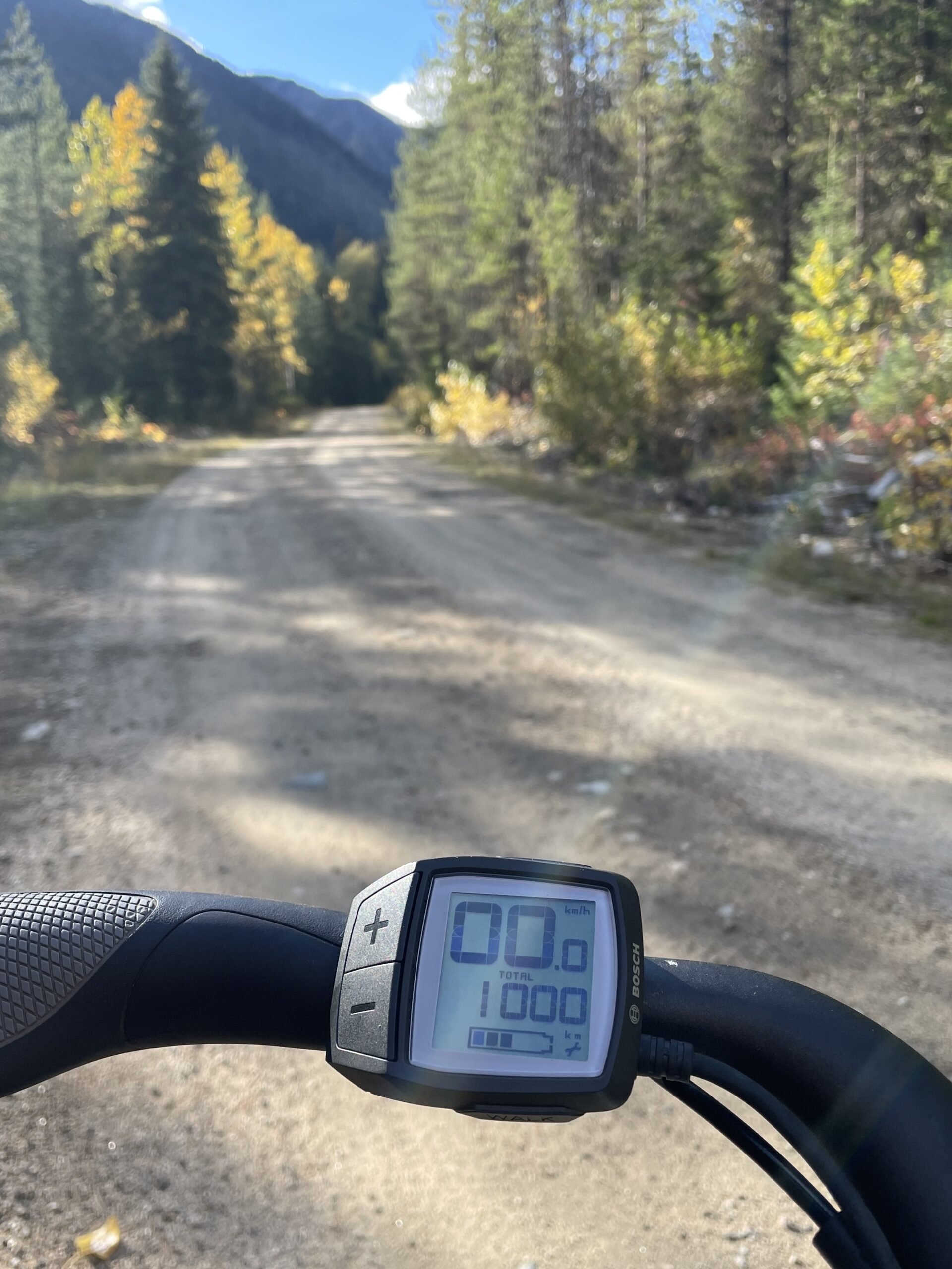
The other day I decided to try out a newly rehabilitated trail in the northwest corner of Kokanee Glacier Park using a recently reopened forestry road for access. To get to the forestry road I had to ride about 20 km from home along the highway to the top of a long hill. I had been assured that the gravel forestry road, just over 12 km long from that point, was in great shape, so there was no reason not to use the e-bike to get to the trailhead. As it turned out it was a great choice.
The 32 km of mostly climbing did give me a twinge of range anxiety. Adding in four hours of alpine hiking, I knew that the climb up the hill back to my house would come at the end of a 7-hour day of non-stop exertion, and I did not want to be running out of bike battery at that point. Having not done a lot of really long rides on the new e-bike I wasn’t sure how much of a cushion I would have, so I kept the power assist either off or — when climbing — on the lowest setting. As it turned out, there was plenty of juice, but I didn’t know that in the morning. Better safe than sorry.
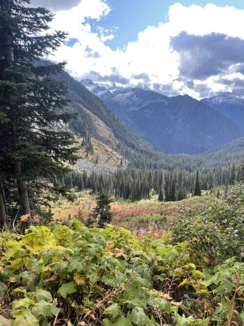
The Roadster turned out to be a very capable Logging-Roadster too. Nice gravel-style tires with a fair bit of volume, some front-fork suspension and a suspension seat-post kept me very comfortable. The hike itself was amazing, though fairly steep, meaning I used muscles on the descent that I don’t stress very often, and I’m a bit sore 36 hours later. But it was worth it to spend a crisp sunny day getting into a beautiful alpine basin that will like get snowed in within a couple of weeks.
Because I was away from home and e-bike for half the summer, it took me until this week to clock 1000 km on the Roadster, and the moment came along the forestry road leading toward Blue Grouse Basin. A great location and a great day for a first major milestone for this bike. Looking forward to many more thousands.
In spring did they notice that alone among the conifers you were fully cloaked trunk to twig in feathery tassels of new green? While other trees merely added pale buds to branch-tips , did they see that you lacked their staid dark under-cladding?
Perhaps they did but in summer you stood in the copse like one of the rest, an apparent evergreen, your trunk driving towards the mountain sky, needles dark and firm like any proper pine or fir. Any suspicions they’d had were put to rest as you set about the photosynthetic business of being a tree. Making roots and cones and twigs, you exhaled oxygen, and soon you too forgot your odd feathery spring.
Yet as the nights grew crisp your suspicions grew that you were not, after all, the same as the rest. Your mid-summer energy spent your needles slowly brittled.
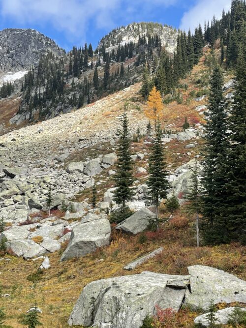
And suddenly one cold morning you were certain that you were not to be ever green after all. You burst into the frost-days of autumn a fiery yellow larch, starkly different, unapologetically so, shouting your gold across the high mountain slopes to others of your kind: I’m here! I’m not like the rest! See me!
Idaho Peak is the mountain that overlooks our property. It’s unique in the area in that despite being one of the highest peaks around, it has well-serviced forestry roads that allow the trail to the peak to be accessible to anyone without major mobility challenges, requiring minimal levels of fitness and stamina. It’s also the ideal launch spot for paragliders. The weekend before SVI I was a marshall and communications relay person for a trail marathon that brought runners through Idaho Peak, and while standing around waiting for the race to complete, I was able to watch a number of paragliders take off. If I had a bucket list, this would be on it.
Last year I carved some time out of July to do a self-powered trip along the Silvery Slocan Circle Route. I did it counter-clockwise over three days, combining kayaking, running and road-biking. This year, with a new-to-me road bike recently acquired, I decided to do the same route all on two wheels. I rode clockwise for a switch, and over two relatively short days. The first day took me over the pass, through Kaslo, down the North Shore of Kootenay Lake to Nelson, for a total of about 112 km and 1700 metres of total climbing. The second day brought me home through the Slocan Valley, for about 100 km and a bit less climbing, about 1500 metres.
Because my overnight waypoint was the Nelson house, I was able to ride almost entirely unencumbered. I carried only water, snack, debit card, phone and my little bike toolkit. Knowing that all the comforts of home were already waiting for me in Nelson was almost as good as having a support team travelling with me!
The weather was great: cool but sunny. The seasons seemed to actually turn while I was riding. On Friday I had noticed that the birch leaves were looking paler as if they were getting ready to turn; by the time I arrived home on Sunday they were yellow and flying off the trees in the wind.
I like giving myself a multi-day solo challenge every year. It gives me time to just be with myself. I come out of it feeling like I’ve accomplished something, renewed. I think this is a tradition I’ll try to continue. I wonder what 2016’s challenge will be?
So here’s how I felt on the third morning: revolting.
Jittery, feverish and nauseated.
The first day was amazing. I had rented a kayak from Smiling Otter in Slocan (my paddling destination) and brought it home the night before, depositing it on the lakeshore. I was on the trail before six for the short run to the lake, catching the first glints of sun sneaking through the Carpenter Creek valley.
First sun: my shadow crossing the Carpenter Creek bridge
It was a hot day but the lake was still in shade and I kept to the east side all morning, tucked into the shade of the mountains. I’d rented a solo touring kayak, much sleeker than our tandem, and made really good time. I’d allotted six to seven hours for the 27k paddle, and finished in four and change. Along the way I saw bald eagles, great blue herons, ospreys, mergansers and countless plovers, swallows, killdeers and such. The lake stayed completely calm until mid morning when some wind blew up. It was pushing me on my way, but the swells and chop were getting rough just as I was passing the cliffs at Cape Horn and knew I had nowhere I could tuck in. I kept checking behind me for the telltale “black line on the lake” that can arrive in ten minutes and capsize unwary boaters who don’t take shelter, but it didn’t come. I pushed hard the last few kilometres just in case, to the river’s mouth, and all was well. I let the river current push me the last couple of kilometres, returned the kayak, donned my shoes and pack, and set off on foot.
Lake mostly shaded by low morning sun
I took the afternoon’s run along the rail trail at an easy pace. I arrived in Winlaw by mid afternoon, hung out by the creek to cool off, then had an extended lunch/dinner at Sissies. Eventually I barefoot-jogged the 4 km to my B&B for the night. My chronic ankle problem had really flared up on the trail, and I wasn’t feeling too optimistic about the next day’s 54km run, but I had a deep sleep and woke up the next morning feeling a lot better.
Rail trail along the river
The next 25k was also along the rail trail. I stopped after a couple of hours for a snack and was very surprised to pick up an unsecured wifi signal, presumably from a nearby house, though I couldn’t see anything. So I had a fun little chat with Fiona. Thanks, whoever you are!
I met a couple of skittish bears and a tiny fawn and a few toads and snakes as well as making a positive ID on a Lazuli Bunting, thanks to my iBird app. Love that app! It also lets me talk to the birds by playing recordings of their songs. They get very intrigued and usually come closer.
Lots of giant black slugs on the rail trail in the morning
The southern part of that day’s run was amazingly hot. The forecast when I left home had been for cooler weather but the thermometer at Taghum at 3:30 that afternoon was in the 90’s. I was in full sun for most of the last four hours and although I stayed well hydrated I felt worse and worse. I suspect I was pretty close to getting heat stroke, as I ended the day nauseated, headachey and feeling weirdly feverish. Couldn’t stomach the idea of dinner. I couldn’t sleep, either, which was odd because I was definitely running a sleep deficit from the two previous nights.
The next morning I decided to do what I’d been toying with the night before: take the bus to my bike, rather than running the 30 km along the west arm of Kootenay Lake. I was still too nauseated to eat, which meant all I’d eaten in the previous 36 hours was a small bowl of granola, a salad wrap and a couple of Luna bars — despite having run more than a marathon. I knew I couldn’t run until I could eat again. I worked into the morning gradually, drank more electrolyte stuff, and more water, and some coffee, sat around a bit, and then hopped on the bus.
On the ferry. My very old bike is awesome, but is currently in need of some TLC.
I jogged to my bike, feeling a little better, and rode back to the highway. This involved a side trip across the Harrop ferry to my friend’s place, which was a nice diversion. A few kilometres later I stopped and managed to eat a bit of late breakfast.
Near the summit of the pass, looking towards home.
The rest of the day was fine. I felt better for the food. The ride to Kaslo was tougher than I expected, the hills more numerous and steeper. I’d been preparing myself for the big pass between Kaslo and home, but as it turned out the hills before Kaslo were steeper (5-10% grade) than the long slow climb over the pass (3-5% grade mostly, and no problem at all). But it was lots cooler on the third day and occasionally drizzly and made for perfect biking weather. I love that road over the pass anyway, thinking of it as my very own highway since it’s the one that our property is on, and I run on it all winter. There are no utility poles most of the way, so it feels high and lonely and wild. The descent was glorious and I whipped along at up to 50 km/h. Cutting off the morning’s run meant I got home in time to pick Noah up from work, cook dinner, eat (yay!) and get Erin to her gig. Watched an episode of The Newsroom with the younger three kids and went to bed before ten.
I’m still a bit nauseated today but except for that I feel pretty good. A couple of blisters here and there, and that yummy feeling of having done something very long and difficult with my body, but pretty much my usual self.
So yeah. Almost a circle. Not going to beat myself up over a small missing arc.
We heard that an injured owl had been found semi-conscious being mobbed by crows in the parking lot of our local grocery store. It had been whisked away and left with Rob, who, along with his wife Linda, is a bit of a birder. So we dropped by the café Rob runs to see if we could have a look. The owl was being kept quiet and warm elsewhere while Rob tried to figure out what to do with it. It turned out that the Orphan WildLife (OWL) rehab centre on the coast was willing to take the owl, and that transport had been arranged through the Trail airport, but that someone was needed to take the owl there for a 4 pm flight.
Having already planned to swing through Castlegar at about 5 pm to find Fiona some dance wear on our way to gymnastics, we volunteered to go a couple of hours early and drive the 25 minutes out of our way to drop the owl off.
He was a great horned fellow, alive and thumping around a little bit in his closed box, but mostly seeming quiet. We were warned that these guys have nasty talons and a grip strength of up to 300 psi, and so not to open the box under any circumstances. We loaded him into the back of the van and headed out. We didn’t get to really look at him, since he was all enclosed, but I did push my iPhone through the breathing hole and take this picture. All puffed up from stress, shying away from the light of my phone. I left him alone after seeing that. Poor guy. But beautiful!
When we arrived in Trail we were surprised to find a local friend waiting for her own medical transport on the same flight. They departed together.
After they left we spent a few minutes updating Rob and Linda, and the veterinary clinic that had offered to overnight the bird if there hadn’t been room for him on the flight, and the OWL Rehab centre, whose volunteers were amazingly helpful and efficient and were already en route to meet him at the other end.
Then we bought dance shoes, tights and leotard (very exciting!) and went to gymnastics.
Although our friend did well with her surgery, we found out a few days later that the owl did not fare so well. He was vastly underweight due to a broken leg that had presumably been preventing him from hunting for some time. He did begin eating well, but an xray revealed that his leg was shattered beyond repair, so he had to be euthanized. A lot of people did their best to help, but it just wasn’t to be.
If you’re in the Lower Mainland, I’m told that the OWL Rehab Centre has excellent educational tours. That will be one of our stops the next time we’re in the neighbourhood.
Armed with three hand-tools — a mattock, a rake and a saw — I have been gradually building a trail from our yard to the Galena Trail. For years I’ve been frustrated by the can’t-get-there-from-here dilemma that separates me from my favourite running trail. We planted a geocache down on the trail more than ten years ago, and the GPS co-ordinates proved what maps had led us to suspect: while it took 25 to 40 minutes to get to that point on the trail, it was only about 175 metres away as the crow flies.
The problem with getting to the trail more directly was two-fold: the grade, and the vegetation. The direct point-to-point grade was about 47%, which puts you somewhere in the realm of a black diamond or double-black-diamond ski run: definitely not the right way to build a trail. And of course trees, bushes and undergrowth had to be circumvented or moved. I ended up with a trail of about half a kilometre long with an average grade of more like 15%. Definitely hike-able both down and up.
It was a curiously addictive process. I would go out planning to spend 45 minutes touching something up and return to the house three hours later. There’s something about actually changing the landscape, of creating something useful out of nothing — well, not out of nothing, but out of nothing that looks like a road or a trail, nothing useful from a human locomotion standpoint. It was like having a superpower: I bisect the wilderness with roads, using my own two hands!
Next year I’ll get to work extending the switchbacks to allow it to be closer to bike-able. If it was manageable on a mountain bike, one could get to town quickly without needing to hit the highway at all.
I’m sure there will be places where the soil will settle and the edges of my trail will need shoring up. I’d love it wider in some places, even for hiking, and there will be oregon grape and wild rose and bedstraw and devil’s club to be tamed continually. But the route is laid out and for now it’s useable on foot. Meaning my favourite running trail is just four minutes away (eight huffing-and-puffing minutes on the way back).
It’s Kootenay Sufferfest weekend. Chuck is away but the girls and I got involved in volunteering the first day. Fiona and Sophie volunteered as marshalling assistants. Fiona was marshalling up-mountain at the halfway First Aid and Marshalling station. She and I sat right at the snow line with slush falling for 7 hours. Plus it took us almost an hour each way to drive the logging roads to get there. So a very long day. But she was awesome: she saved the day a couple of times when the adults had got too distracted by communications issues to note a bib number on a racer.
The experience played right into her wilderness skills homeschooling project what with the various pre-race first aid and marshalling planning meetings, the communications relaying (we’re way out of cellphone range, and sat-phones were unreliable in places because of terrain) and keeping an eye on runners and riders for signs of hypothermia, and watching and helping them avoid succumbing to the elements. We had a market tent, which helped keep us from getting soaked the skin, and also took our Biolite stove and made hot chocolate for runners and volunteers alike. I was working first-aid, and thankfully there was nothing more than minor stuff; a few of the bikers who looked in danger of getting hypothermic during the first loop judiciously dropped out of the race before attempting the second pass, and none of the die-hards got into difficulty. Not that there weren’t some serious worries by the organizers. It was so cold, and there was a lot of snow up high. The Idaho Peak Run came off just fine: 14 runners finished. But the early snow made for a lot more challenge and hazard than had been expected. I’m glad this hadn’t turned out to be the year for me to attempt that run.
Sophie helped marshal the first and last runner aid stations. She and her marshalling buddy were on foot, carrying water and food since there was no road access. The race director and I had used backpacks and bike trailers to haul in some of the gear the day before, but they still had to carry some. They also had almost no radio or satellite phone contact, so were very isolated. They had a really long day. Sophie had left home by 7 am, and hadn’t surfaced again by 4 pm. I made a thermos of hot mochas, and took to the trail to run out and meet them. I met them at the halfway point of their hike out. I was very glad to see them still upright and coherent!
Me (#493) and some of my running buddies, keeping warm in the rain and mud pre-race.
Today I went over to Kaslo and ran the 10k Sufferfest trail race. I did surprisingly well: I got 1st place in my age-group (40th place overall). It wasn’t a big race — under 200 participants — but I was really pleased by how strong I felt. I haven’t run much the past few months, but I have done a bit of strength training, which is new for me.
I haven’t run a race shorter than a half-marathon in more than 3 years and I really enjoyed the shorter distance. It was rainy, mucky and slippery, with lots of little steep hills, so the times weren’t that fast, but I got in in under an hour. The push up the hill for the finish left me feeling spent, but within ten minutes felt pretty much fully recovered and felt like I could have run a lot farther. Maybe next year I’ll go back to running the 25k. Or maybe not. At this point I find that a 10k doesn’t really require any training more than my haphazard recreational running, and that’s nice.
Fiona and I have been visiting the trees in the forest that surrounds our home recently, appreciating them anew as they emerge from the snow and prepare for a new season of growth.
Yesterday we checked out the red cedar bark, which we will use for basket weaving. Years ago the kids did a workshop with this lovely local lady, and while they’re a lot of work, the tiny baskets we have since made have been very striking and rewarding. It’s still too early in the season for it to come away easily in long strips, but we’re looking forward to harvesting some in May. We then dug up some red cedar roots, to decide how useful they’d be for embellishing our baskets. I had read that they make great sewing material, but had never taken the suggestion seriously. They really are amazing. The slenderest ones are strong, pliable and lovely to look at, and they dry and increase in strength very quickly once harvested.
We collected armloads of white pine cones to use a fire-starter next winter.
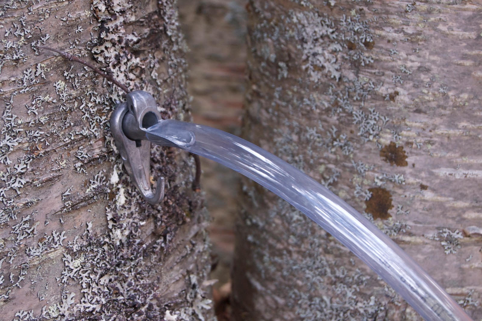
And then we made our acquaintance again with the birch trees. We tapped a couple of birch trees years ago, but our sap collection set-up wasn’t ideal and we didn’t get enough sap to make a proper syrup. Because birch sap is about five times less sugary than maple sap, you need a heck of a lot of it!
Sometime in the intervening years I managed to purchase four spiles and today we picked up some clear 1/2″ tubing at the local hardware store. All it took was a quick bit of work with the portable drill and a couple of taps with the mallet the trees began spilling their sap out for us with eagerness. We plugged a couple of tubes into each of two glass carboys and within an hour or two had a couple of gallons of sap.
I imagine it will be incredibly time- and energy-consuming to boil the stuff down, but I’m happy to do it just once, to experience the process and the taste of the syrup.
Birch sap is sterile and contains trace amounts of minerals, xylitol and various other good things. It’s actually a great source of safe drinking water. Not that we don’t already have safe drinking water, but hey, when civilization crumbles, this might be a useful piece of knowledge.
The lake at the summit north of us has frozen clear, without snow. It’s not quite glassy, but quite skate-able. We’ve opted not to flood our backyard rink this year, so there’s even more reason for the trip to the lake to be worth doing.
Fiona and I skated all the way across, and all the way back, and then spent some time “doing doodly-do’s” around the near shore. She found her skating legs quickly and despite the wind we both managed to generate enough body heat to stay toasty warm for an hour.
While we were holed up in a “cave” beneath a rock, out of the wind on the far side of the lake, a coyote trotted directly in front of us, oblivious to our presence.